Sunapee

Lake Sunapee is located within Sullivan County and Merrimack County in western New Hampshire, the United States. It is the fifth-largest lake located entirely in New Hampshire.
The lake is approximately 8.1 miles (13.0 km) long (north-south) and from 0.5 to 2.5 miles (4.0 km) wide (east-west), covering 6.5 square miles (4,136 acres)[1], with a maximum depth of 142 feet (43 m). It contains eight islands (Great Island, Burkehaven Island, Star Island, Little Island, Loon Lighthouse Island, Emerald Island, Treasure Island and Minute Island) and is indented by several peninsulas and lake fingers, a combination which yields a total shoreline of some 70 miles (110 km). There are seven sandy beach areas including Mount Sunapee State Park beach; some with restricted town access. There are six boat ramps to access the lake at Sunapee Harbor, Georges Mills, Newbury and Mount Sunapee State Park, Burkehaven Marina, and a private marina. The lake contains three lighthouses on the National register. The driving distance around the lake is 25 miles (40 km) with many miles of lake water view. The lake is 1,093 feet (333 m) above sea level.
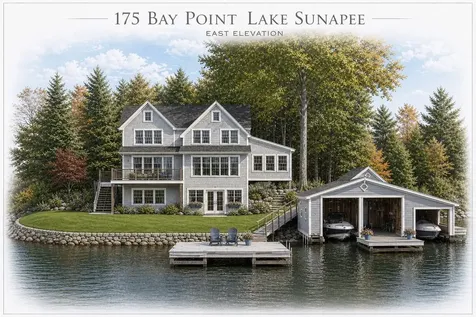
$5,995,000
Newbury, NH
175 Bay Point Road
- 4 Beds
- 5 Baths
- 53 Acres
- 3,765 SqFt
- 74 Days on Market
$4,395,000
Sunapee, NH
78 Garnet Street
- 5 Beds
- 6 Baths
- 0.25 Acres
- 4,261 SqFt
- 78 Days on Market
For more info. click herer fo rthe Lake Sunapee Chamber of Commerce
For more info on the lake itself, click here


Copyright 2026 PrimeMLS, Inc. All rights reserved. This information is deemed reliable, but not guaranteed. The data relating to real estate displayed on this display comes in part from the IDX Program of PrimeMLS. The information being provided is for consumers’ personal, non-commercial use and may not be used for any purpose other than to identify prospective properties consumers may be interested in purchasing. Data last updated July 15, 2026 10:40 AM EDT